


9915352-AUBRAC 2019 - 3 - RaG

mic-13
User
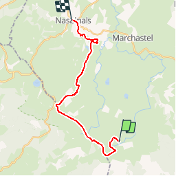

Length
19.8 km

Max alt
1467 m

Uphill gradient
273 m
Km-Effort
24 km

Min alt
1172 m

Downhill gradient
429 m
Boucle
No
Creation date :
2019-05-18 07:56:01.305
Updated on :
2019-05-18 07:57:21.445
5h07
Difficulty : Medium

FREE GPS app for hiking
 SityTrail
IGN / Geographical institutes
SityTrail Plus
The world is yours!
About
Trail Walking of 19.8 km to be discovered at Occitania, Lozère, Les Salces. This trail is proposed by mic-13.


Positioning
Country:
France
Region :
Occitania
Department/Province :
Lozère
Municipality :
Les Salces
Location:
Unknown
Start:(Dec)
Start:(UTM)
507343 ; 4935882 (31T) N.
Comments